For roadies in the Cold Dark North the fringes of the Forest of Bowland feature three testing and beautiful road climbs - the "only" ways into the Forest from the North West corner - the Trough of Bowland, Lythe Fell (aka the "Cross o Greet") and Bowland Knotts. That's it. That's plenty.
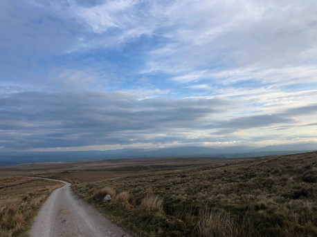
But the MTB'ers, GRVL folk and the Grouse shooters have long since thought they know better. They've known the Old Salt Road from High Salter to Slaidburn. Part Roman road in the South, loose-packed gravel and rocks for sections and glorious white gravel for the most part - this 8 mile stretch of "rough stuff" should be enough to turn even the most ardent roadie a little gooey.
We've been planning a ride over this relatively unknown and fabled track for a while - friends like Second City Divide and Unpaved have wanged on about it. And frankly it was a little embarrassing not to have at least attempted it. So when we picked up a copy of Jack Thurston's new book, Lost Lanes North, we were immediately drawn to route #29 - or "Take the High Road" - an 80km loop from Lancaster to Slaidburn and back taking in this crucial gravel parcours and then returning via our favourite local climb the Cross o Greet. The relative easing of lockdown in the UK gave a perfect opportunity to see for ourselves what all the fuss was about.

Taking on the Old Salt Road
Jack's route starts and finishes in Lancaster and we've adapted it very slightly below. Our ride doesn't pick up that route until the pretty little Methodist Church at Roeburndale - from Lancaster you'll already have battled some beautiful rugged landscape over Caton Moor and up to Roeburndale itself. We set off at 5.30am, allowing for a perfect view of the sunrise over the distant Yorkshire Dales as we climbed (seemingly endlessly) from Hornby up towards Low, Middle and eventually High Salter. A series of ever more desolate farms that signal the start of your journey into the wilderness of the Old Salt Road.
Past the last of the farms (at 18km) you are through a gate and immediately onto the open tightly packed white gravel. Wending its way curvaceous through the soft rolling peaks of the landscape in front of you, the track can be seen for miles ahead. There is still a fair bit of climbing to be done before you reach the 400m+ peak of elevation. Occasional sightings of ludicrously steep tributary tracks and the occasional gate, sheep or hare are all that interrupt the silence and solitude. It's a magical place. And that's before we get onto the witching heritage of these Pendle Hills.
The going up here isn't easy. But the gravel for the first 2 miles is pristine. "Primo". Easy going even for a roadie. Then you reach another gate and suddenly the gnarl-dial gets turned up a bit. Still mostly rideable, this a little more challenging. Occasional sections of jumping off to hike-a-bike for a minute or two aside, momentum is maintained for most of the ascent.
But as the road skirts around White Hill to the North, the descent starts and the nerves begin to jangle. This is going to be a tense affair. A lot of riding in the verge, white-knuckle near misses and moments questioning the logic of a dawn raid on a vast empty Fell later and we've made it to the Witches 400 waymarker below Baxton Fell. From there the going is much easier for about 2km before you're back on tarmac. Happy to admit that return came with some relief, but the Old Salt Road had done the trick. It is an adventure best shared with others, when we're allowed. But it was a "proper" road. Worthy of everyone's "to ride" list.

You couldn't do this on a road bike. In fact, you'll be best on 35+mm tyres with a decent amount of grip. And padded gloves. And some cajones. ;)
Beyond the Salt Road, we descended into the beautiful Forest of Bowland village of Slaidburn before turning for the long road home. It's easy to underestimate the stretch from Slaidburn to the foot of the Cross. The tarmac may increase the speed but the relentless stabby-climbing alongside the River Hodder to the beautiful open views above Stocks Reservoir are sapping.
And then you finally have the majesty of the Cross o Greet unfurled ahead of you. Never too steep. Always exposed to the elements, whether warm sun, driving rain or wind (often a headwind!). It's a belter. We saw young deer sprinting across the valley as we rode up at in the morning sunshine. We didn't see a single car. It's a 15-20 minute effort and the reward is a beautiful fast and vast descent down the other side toward Bentham. Ahead of you now are never-ending views of Ingleborough, Whernside and the peaks of The Yorkshire Dales.

After a rapid loss of altitude, the route starts to wind West through Wray, Hornby and Gressingham, crossing the Loyne Bridge and then following the Lune River back to Lancaster. You'll have earned your tea after this ride. It's a sapping, sinuous, salty stunner.

If you'd like any help planning caf/refuel stops along the way, let us know.
Here's the route we'd recommend - starting and finishing at the Train Station in Lancaster.
81km, 1,300m^. Really tough. Really worth it.


Comments